The problem has gotten harder, fast. The satellite industry closed out 2025 with 14,266 operational satellites in orbit after deploying 4,434 satellites during the year alone, a 65% jump over 2024. Most of that growth is happening in low and medium Earth orbit, where satellites move relative to the ground and fixed-point antennas simply can't keep a lock.
For defense, maritime, and aviation operators, tracking capability isn't a nice-to-have. It's the difference between a live link and a dead one mid-mission. This article covers what tracking antennas are, how they work, the tracking methods available, GNSS accuracy realities, where they're deployed, and how to choose the right one.
Key Takeaways
- Tracking antennas hold lock by continuously recalculating azimuth and elevation
- Four core tracking methods (manual/programmed, step-track, mono-pulse, cone-scan) each trade speed against cost
- Standard GPS delivers meter-level accuracy; RTK-augmented GNSS reaches centimeter-level precision
- Beamwidth accuracy drives tracking precision and needs re-verification after component swaps
- Antenna choice hinges on frequency band, tracking method, ruggedness, and mission-specific pointing accuracy
What Is a Satellite Tracking Antenna?
A satellite tracking antenna continuously reorients itself, using a positioner that controls azimuth and elevation, to follow a moving signal source and hold peak signal strength. Rather than aiming at one fixed point in the sky, it recalculates its target position constantly and physically moves to match it.
Fixed antennas work when the satellite is geostationary and the ground point never moves. Tracking antennas become necessary when the satellite is non-geostationary (LEO or MEO) or the platform itself (a ship, aircraft, or vehicle) is in motion.
Every tracking system, regardless of application, relies on four core components:
- Reflector/feed assembly — captures and focuses RF energy at the target frequency band
- Positioner/pedestal — the motorized mount, typically azimuth-over-elevation, that physically moves the antenna
- Antenna Control Unit (ACU) — the system's brain, running the tracking algorithm and driving positioner motors
- Beacon or signal-strength receiver — supplies the feedback signal that makes closed-loop tracking possible
Tracking antennas show up in two very different contexts. Fixed ground stations and teleports use them to follow moving satellites across the sky. Mobile platforms use them to hold a lock on a satellite (moving or fixed) while the platform itself is rolling, pitching, or changing heading.
Meeting either demand takes specialized engineering, not a catalog part. Micro-Ant has spent more than 20 years engineering bespoke tracking antenna systems out of its AS9100:2016 and ISO 9001:2015 certified Jacksonville, Florida facility. The company builds custom platforms for defense, aviation, maritime, and land applications instead of pulling from a generic catalog.
How Satellite Tracking Antennas Work
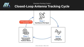
Satellite tracking relies on a closed feedback loop that repeats continuously, often many times per second on fast-moving platforms:
- The antenna control system reads a beacon or pilot signal from the target satellite.
- It calculates how far off-target the beam has drifted.
- It sends correction commands to the positioner motors to re-center the beam on the source.
The Role of Beamwidth in Tracking Accuracy
The antenna's -3dB (half-power) beamwidth is a foundational input to that correction math. It tells the control system how big or small each corrective step should be.
Get the beamwidth value wrong, and the system overshoots or undershoots the target repeatedly, chasing the signal instead of locking onto it. As one JPL analysis noted, normal conical-scan pointing accuracy runs around 5 millidegrees for S/X-band operation. That figure only holds, though, if the antenna's actual beamwidth matches what the control system assumes.
That's why beamwidth needs to be reverified whenever major components (feed, panels, or controller) are serviced or replaced. Skipping this step is one of the most common causes of unexplained tracking degradation in the field.
Fixed Ground Stations vs. Mobile/On-the-Move Tracking
Beamwidth accuracy requirements shift depending on what's doing the tracking. A fixed ground station tracking a GEO or MEO satellite deals with slow, predictable motion, and the satellite's path is known well in advance, so pointing corrections stay gradual.
On a moving vessel, aircraft, or vehicle, it's a different problem entirely. Platform motion (roll, pitch, yaw, and translation) compounds on top of satellite motion, and the antenna has to compensate for both simultaneously.
Because of this compounding effect, defense and maritime satcom-on-the-move terminals depend on ruggedized, high-dynamic-response designs. General Dynamics' SATCOM-on-the-Move terminal, for example, is built to hold under 0.20 degrees of pointing accuracy 99% of the time under specified motion conditions.
Types of Antenna Tracking Methods
Tracking methods split into two broad categories: manual/programmed approaches that rely on operator input or predicted orbit data, and automatic/closed-loop methods that continuously correct based on live signal feedback.
Manual and Programmed Tracking
Manual tracking means an operator adjusts pointing directly to maximize signal strength, useful as a backup but too slow for most operational use. Programmed tracking instead loads pre-calculated ephemeris data into the ACU, which drives the positioner along a predicted path without needing a beacon receiver at all. Both methods are commonly kept as fallback options behind an automatic tracking mode.
Step-Track (Sequential) Tracking
Step-track nudges the antenna along azimuth, checks signal strength, nudges along elevation, checks again, and repeats, converging on peak signal through sequential trial and error. It's low-cost and mechanically simple, which makes it popular for less demanding applications. The trade-off: it's slower and less precise than methods that measure pointing error directly.
Mono-Pulse (Simultaneous) Tracking
Mono-pulse uses multiple feeds to generate sum and difference beams simultaneously, estimating angular pointing error in a single measurement instead of a sequence of steps. NASA's JPL developed monopulse specifically because step-track and conical-scan methods couldn't meet the tighter pointing demands of Ka-band operation.
It's faster and more accurate, but also more complex and more expensive, commonly found in large earth stations and shipborne terminals where precision justifies the cost. Micro-Ant engineers mono-pulse tracking into its shipborne SATCOM terminals, built to hold lock in the maritime environments where that precision matters most.
Cone-Scan Tracking
Cone-scan (conical scan) oscillates the beam in a small circle around boresight, using the resulting signal variation to derive pointing error. It functions similarly to monopulse but on a time-sharing basis rather than simultaneously, making it a middle-ground option relevant to on-the-move and mobile satcom terminals.
Comparing the Methods
| Method | Relative Accuracy | Relative Cost | Best Fit |
|---|---|---|---|
| Manual/Programmed | Low (no live feedback) | Low | Backup mode, predictable GEO/MEO paths |
| Step-Track | Moderate | Low-moderate | Cost-sensitive, slower-moving targets |
| Cone-Scan | ~5 mdeg (S/X-band) | Moderate | Mobile terminals needing faster response than step-track |
| Mono-Pulse | Highest (sub-mdeg achievable at Ka-band) | High | Large earth stations, shipborne terminals, Ka-band missions |
How Accurate Are GPS and GNSS Tracking Antennas?
Accuracy expectations here vary enormously depending on the technology behind them. A standard smartphone GPS receiver is typically accurate within a 4.9-meter radius under open sky conditions, and that number gets worse near buildings, bridges, or dense tree cover.
Augmented systems change the picture entirely. According to EUSPA's PPP-RTK market and technology report, real-time kinematic (RTK) correction can achieve accuracy of up to 1 centimeter plus 1 part per million, a leap from meter-level to centimeter-level positioning.
The gap between these tiers is clear side by side:
| System Type | Typical Accuracy | Common Use Case |
|---|---|---|
| Standard smartphone GPS | ~4.9 m radius | Consumer navigation |
| RTK-corrected GNSS | 1 cm + 1 ppm | Surveying, precision agriculture |
| Phase-stable GNSS antennas | Sub-centimeter, constellation-independent | Defense and mission-critical tracking |
None of these figures hold up perfectly once a system leaves lab conditions. Several factors degrade real-world GNSS accuracy regardless of receiver quality:
- Multipath interference: Signals bouncing off buildings, terrain, or vessel structures before reaching the antenna
- Atmospheric distortion: Ionospheric and tropospheric delays that shift signal timing
- Satellite geometry: Poor dilution-of-precision when visible satellites cluster in the sky rather than spreading out
- Phase center stability: The electrical reference point shifting slightly with signal angle, an effect high-precision systems can't tolerate
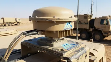
Micro-Ant's proprietary high-precision GNSS antenna designs support multiple satellite constellations and are engineered specifically to minimize these error sources, giving defense and civil operators the phase-center stability that separates consumer-grade GNSS from mission-grade positioning.
Real-World Applications of Satellite Tracking Antennas
Tracking antennas show up wherever a signal has to stay locked despite motion — on the platform, the satellite, or both.
| Sector | How Tracking Antennas Are Used |
|---|---|
| Defense & Government | Secure satcom-on-the-move terminals and intelligence community ground systems requiring rugged, high-reliability tracking under field conditions |
| Maritime | Stabilized shipborne antennas maintaining links with MEO/GEO constellations, including SES's O3b mPower system, despite constant vessel motion |
| Aviation | In-flight connectivity antennas tracking satellites continuously as aircraft change heading, altitude, and position |
| Autonomous vehicles, agriculture, construction | GNSS tracking antennas enabling centimeter-level positioning for guidance and navigation systems |
Maritime deployments illustrate why this matters. A vessel rolls and pitches in ocean swells while the satellite itself may be tracing a MEO path across the sky.
The antenna has to solve both problems at once, continuously, for the entire voyage:
- Compensates for vessel roll, pitch, and yaw in real time
- Tracks the satellite's independent orbital motion simultaneously
- Maintains lock without interruption across multi-day voyages
Micro-Ant's roster of satellite communications customers, including SES, Eutelsat, Intelsat, and Iridium, reflects how broadly this challenge spans commercial and government fleets alike.
How to Choose the Right Satellite Tracking Antenna
Selecting a tracking antenna comes down to matching the system to the mission, not just the frequency band. Key criteria include:
- Required frequency band(s): Ku, Ka, X, or multi-band roaming across operators
- Tracking method: step-track for cost-sensitive applications, mono-pulse for high-precision or fast-moving targets
- Environmental ruggedness: shock, vibration, and temperature tolerance for field or shipboard deployment
- Size and weight constraints: critical for airborne and manpack applications
- Required pointing accuracy: driven by beamwidth and mission tolerance for signal loss
These criteria shape the design, but validation matters just as much. Near-field chamber measurements confirm beamwidth and pointing accuracy before deployment, catching problems that would be far costlier to fix in the field.
Micro-Ant's in-house spherical and planar near-field testing chambers cover 750MHz to 40GHz for this reason: verifying performance before an antenna ever leaves the facility.
Not every mission requires a custom build. The table below shows when off-the-shelf hardware fits and when bespoke engineering pays for itself:
| Approach | Best Fit |
|---|---|
| Off-the-shelf | Straightforward, single-operator applications |
| Bespoke engineering | Extended Ka-band roaming across multiple satellite operators, or ruggedization beyond standard commercial ratings |
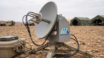
Micro-Ant's Ultra-Wide Band Ka Antenna System was built for exactly this kind of multi-operator roaming. It reflects the custom design work that over 20 years of antenna engineering makes possible.
Frequently Asked Questions
What is a tracking antenna?
A tracking antenna is an antenna system that automatically or manually reorients itself to follow a moving satellite or compensate for platform motion, maintaining optimal signal strength throughout the connection.
What are the different types of antenna tracking methods?
The primary categories are manual/programmed, step-track, mono-pulse, and cone-scan tracking. Accuracy increases with complexity and cost, with mono-pulse offering the highest precision at the greatest expense.
How accurate are GPS antennas?
Standard GPS typically delivers accuracy within a 4.9-meter radius under open sky, while RTK-augmented GNSS can reach up to 1 centimeter plus 1 part per million. The gap between the two is significant for precision applications.
What's the difference between a fixed satellite antenna and a tracking antenna?
Fixed antennas only work for stationary GEO links viewed from a fixed point on the ground. Tracking antennas actively reposition to follow moving satellites or compensate for platform motion on ships, aircraft, or vehicles.
Can one tracking antenna work with multiple satellite constellations?
Yes. Multi-band, wideband designs, such as extended Ka-band roaming systems, allow a single antenna to connect across multiple satellite operators and constellations without swapping hardware.
How often should a tracking antenna's beamwidth be measured or verified?
Beamwidth should be reverified whenever the feed, panels, or controller are serviced or replaced, and any time tracking performance degrades without an obvious cause.